Unlike anything else
Fiordland National Park was officially constituted in 1952 and became a UNESCO World Heritage site in 1986. Today, the park is part of Te Wahipounamu South West New Zealand/The place of Greenstone which incorporates Aoraki/Mt Cook, Fiordland, Mt Aspiring and Westland National Parks. One of only three World Heritage sites in New Zealand, Te Wahipounamu is described as an area of 'superlative natural phenomena' and 'outstanding examples of the earth's evolutionary history'.
But Fiordland had a long and active past before humans were ever able to lay eyes upon it.
A land of uplift and ice ages
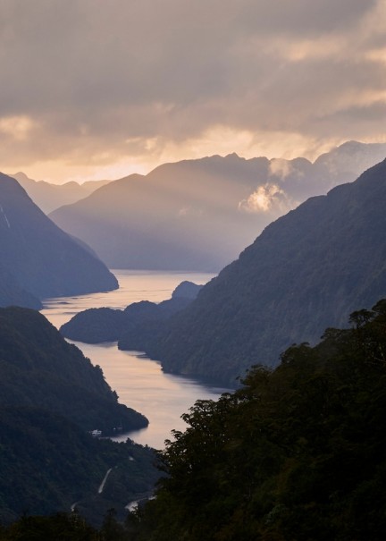
The ongoing collision between the Indo-Australian and the Pacific Continental plates is evident by the sight of the mighty Ka Tiritiri-o-te-Moana/Southern Alps. Like the backbone of the South Island, this mountain range runs from top to bottom, reaching 4,000 metres (2.5 miles) at its highest point. Fourteen fiords carve deep indentations into the dense Fiordland coastline.
The towering peaks we see today were once compacted layers of sediment found on the seafloor. Periods of uplift which occurred hundreds of millions of years ago lifted the seafloor right out of the water, only to have it sink millennia later during a time of submergence.
Around 100 million years ago, the slow and steady work of the glaciers began to shape a new landscape. As the glaciers carved their way towards the sea, they gouged out the lakes and steep fiords Fiordland is now famous for. Mountain sides scarred by glacial striation, hanging valleys and vast fiords are the tell-tale signs of this powerful glaciation period. What was left behind is a majestic landscape and one of only four places on the planet where fiords are found.
To Māori, Fiordland is known as Te Rua-o-te-moko, A place of towering peaks and plunging valleys, a place where light and shadow create beauty and intrigue.
Few Māori were permanent residents of the region, but well-worn trails linked seasonal food-gathering camps. Takiwai, a translucent greenstone or New Zealand jade, was sought from Anita Bay and elsewhere near the mouth of Milford Sound.
Piopiotahi / Milford Sound after a storm - Douglas Thorne
A LINK TO THE PAST
As the best intact representation of the flora and fauna of Gondwanaland, Te Wahipounamu South West New Zealand is recognised as being of ‘global significance’. New Zealand separated from Gondwana long before the appearance of marsupials and mammals. Its long isolation is the reason New Zealand has a wide diversity of birdlife, many of which are flightless or have limited flight.
Before the introduction of predatory pests like deer, ferrets and stoats, the fauna of Fiordland enjoyed evolutionary isolation, and eventually lost the need to fly. Today, many of the park’s native birds are on the endangered list, making the World Heritage listing even more important.
Within Fiordland National Park, some very special native species are protected. Find out more about Fiordland’s native flora and fauna here.
Over the years, visitors have arrived in Fiordland in ever-growing numbers to see for themselves the area’s famed beauty. Thanks to New Zealand’s strong sense of conservation, places of natural beauty such as Fiordland National Park will be preserved and protected by those who live, work and visit here. It is a way to ensure all those who visit Fiordland will experience the very same wild majesty that early Māori and the tourism pioneers encountered.