Pearl Harbour - Frasers Beach
Duration: 30 minutes
The track starts or finishes from Pearl Harbour, the departure point for cruise trips to Patea / Doubtful Sound, or at the road entrance just north of Manapouri township. Enjoy an easy walk along the beach, or the track parallel to the beach and take in the spectacular views of Fiordland National Park.
**Dog friendly**
Home Creek Walk
Duration: 30 minutes
Home Creek is a unique natural meandering stream draining to the Waiau River. This easy loop track is located 1-kilometre east of Manapouri township. Look out for the signposted public road off Hillside-Manapouri Road.
Rakatu Wetlands
Duration: 30 minutes
These spring-fed remnant wetlands were created to mitigate the effects of the Manapouri hydroelectric power scheme on the Waiau River. The wetlands are now internationally recognised and are home to fish (both native fish and introduced trout), waterfowl and protected birds.
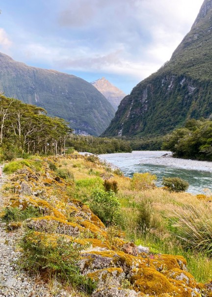
Access to the following walking tracks requires crossing the Waiau River at Pearl Harbour to the jetty on the opposite shore. There are water taxis available, or rowboats can be hired.
Circle Track
Duration: 3 - 3.5 hours
A water taxi or private boat is required to the start of the track at the jetty opposite Pearl Harbour. From the jetty, follow the riverside track for 15 minutes to a track junction. Turn left and head up the hill to the viewpoint overlooking the lake. This part of the track is steep and slippery so take care. The track then descends the ridgeline to the Hope Arm Track. Turn right to return to Pearl Harbour, which takes about 1 hour. Alternatively, turn left for Hope Arm or Back Valley Hut options.
Pearl Harbour to Hope Arm
Duration: 4 - 6 hours return
A water taxi or private boat is required to the start of the track at the jetty opposite Pearl Harbour. From the jetty, follow the track by the Waiau River for 15 minutes. A signposted junction indicating the Circle Track is to the left – carry on straight ahead. There are good views of the Manapouri boat harbour from the terraces above the river. The track follows close to the lake edge in several places, and there are some unofficial tracks that lead to the lake itself. From here the track climbs gently to the spur where the Circle Track rejoins the main track. Continue straight ahead again through the diverse understorey of plants until reaching the Back Valley/Hope Arm Hut junction. Turn right for Hope Arm and proceed through a narrow neck of the forest on boardwalks over swampland. Cross the bridge over the Garnock Burn before descending into Hope Arm Beach. The hut is at the far end of the beach.
Mt. Burns
Duration: 4 hours return walk (1.5 hour drive to Borland Saddle)
From Manapouri, follow the Southern Scenic Route toward Tuatapere. About 45 45-minute drive from Manapour, I turn right onto the Borland Road. The road is mostly unsealed, and in the winter, it is gated beyond Borland Lodge. When the road is open, follow it with care to the Borland Saddle, approximately 45 minutes to 1 hour from the main road turn off. From here, park your vehicle and ascend through stunted beech forest to the alpine area. You will require a map (available from the Department of Conservation) to make your way through the beautiful red tussock, past alpine tarns (small ponds) and along the ridgelines to the summit of Mt. Burns.